Log in
All resources
Create a design
191 Free Artworks of Maps Of The Rhine
bibliothèque nationale de france
guillaume sanson
maps of the course of the rhine by guillaume sanson
maps of alsace by guillaume sanson
maps of moers by johannes mercator
maps of bonn by braun & hogenberg
maps of vangiones by sanson
maps of the county of mark
maps of the ruhr area
maps by john cary
1700s maps of rhineland-palatinate
maps of east palatinate by sanson
tombleson's views of the rhine (1832)
loreley in art
1757 in north rhine-westphalia
old maps of wesel
old maps of the principality of minden
1840s maps of north rhine-westphalia
paintings by adolph von menzel
realism
maps of arnhem by braun & hogenberg
maps of venlo by braun & hogenberg
david rumsey historical map collection
1794 maps of the holy roman empire
david rumsey historical map collection
1790s maps of the holy roman empire
old maps of westphalia
johannes gigas
maps of the land of valkenburg
guillaume sanson
maps of the land of valkenburg
guillaume sanson
maps of the course of the rhine by guillaume sanson
bibliothèque nationale de france
maps of alsace by guillaume sanson
1660s maps of baden-württemberg
maps of alsace by guillaume sanson
1660s maps of alsace
gütersloh in the 18th century
history of gütersloh
maps of moers by johannes mercator
old maps of duisburg
maps of the course of the rhine by guillaume sanson
bibliothèque nationale de france
map of the upper rhenian circle by sanson
maps by nicolas sanson
demolished castles in landkreis germersheim
neuburg am rhein
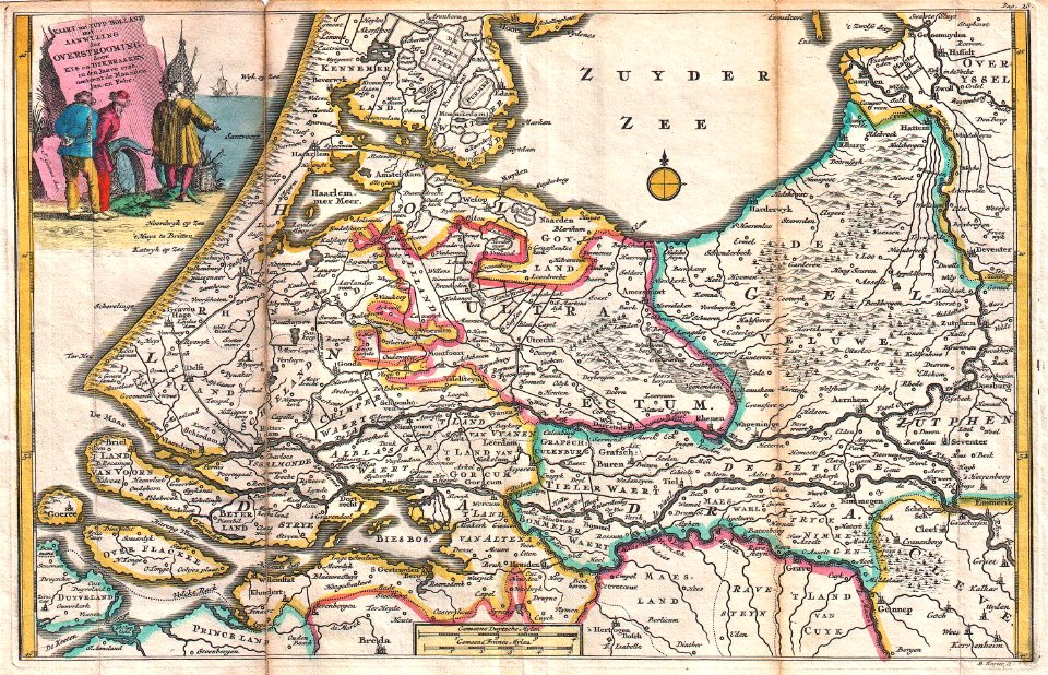
1720s maps of the netherlands
1726 maps
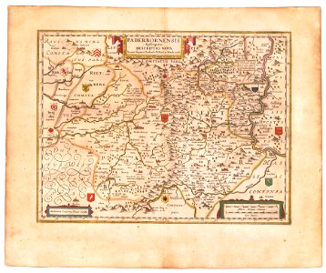
old maps of prince-bishopric of paderborn
johannes gigas
maps by christian sgrothen
bibliothèque nationale de france
guillaume sanson
maps of the palatinate of the rhine
pieter van der keere
maps of neuss by braun & hogenberg
maps of bonn by braun & hogenberg
maps of neuss by braun & hogenberg
maps of bonn by braun & hogenberg
1770s maps of rhineland-palatinate
maps of east palatinate by sanson
maps by christian sgrothen
rheindahlen
nicolaus person
rhenish hesse
1670s maps of rhineland-palatinate
maps of vangiones by sanson
territorium argentoratense (1652 map)
bibliothèque nationale de france
description de l'universe
alain manesson mallet
guillaume sanson
1674 maps
maps of the course of the rhine by guillaume sanson
bibliothèque nationale de france
1804 maps of europe
maps by john cary
maps by john cary
1799 maps
territorium argentoratense (1652 map)
context files from gallica
sanson maps of the circles of germany
bibliothèque nationale de france
sanson maps of the circles of germany
bibliothèque nationale de france
atlas ou representation du monde universel t. 2 (1633)
maps by hendrik hondius the younger
old maps of swabia
maps by john cary
bibliothèque nationale de france
guillaume sanson
1670s maps of rhineland-palatinate
maps of vangiones by sanson
description de l'universe
1685 maps of europe
historic views of speyer
wilhelm besserer
maps of moers by johannes mercator
bibliothèque nationale de france
maps of aachen by braun & hogenberg
bibliothèque nationale de france
maps of werden by braun & hogenberg
maps of essen by braun & hogenberg
1660s maps of rhineland-palatinate
maps of vangiones by sanson
maps of the course of the rhine by guillaume sanson
guillaume sanson
maps from the earth and its inhabitants, vol. iii
maps of the rhine
maps of aachen by braun & hogenberg
bibliothèque nationale de france
maps of hunsrück
jean hardy
cartouche (cartography)
jean-claude dezauche
maps of dillenburg by braun & hogenberg
maps of siegen by braun & hogenberg
maps of werden by braun & hogenberg
maps of essen by braun & hogenberg
old maps of emmerich am rhein
baroque
maps from the earth and its inhabitants, vol. iii
old maps of the rhine
maps from the earth and its inhabitants, vol. iii
old maps of the rhine
old maps of the rhineland
maps by gerard de jode
maps of moers by johannes mercator
bibliothèque nationale de france
maps of haguenau
carolus allard
cartouches by alexis-hubert jaillot
cartouches by sanson family
atlas ou representation du monde universel t. 2 (1633)
maps by hendrik hondius the younger
maps of the county of mark
guillaume sanson
fossa sanctae mariae quae et eugeniana dicitur vulgo de nieuwe grift - btv1b532255218
maps of venlo by willem and johannes blaeu
sanson maps of the netherlands
alexis-hubert jaillot
maps of strasbourg in the 17th century
gerard jollain
sanson maps of the circles of germany
1670s maps of baden-württemberg
maps of cologne by braun & hogenberg
bibliothèque nationale de france
maps of cologne by braun & hogenberg
bibliothèque nationale de france
maps of alsace by guillaume sanson
guillaume sanson
le comté de la marck, les seigneuries des abbayes de werden, d'essen et la ville impériale de dortmundt - dressé sur les mémoires les plus récents par le sieur sanson... - btv1b532024306
guillaume sanson
maps of bonn by braun & hogenberg
bibliothèque nationale de france
maps of the palatinate of the rhine
1692 maps of rhineland-palatinate
engravings by matthäus merian
baroque
drawings by simon fokke in the rijksmuseum amsterdam
design drawings in the rijksmuseum amsterdam
maps of aachen by braun & hogenberg
bibliothèque nationale de france
old maps of duchy of cleves
guillaume sanson
les duchés de cleves, juliers, limbourg (etc.) by jaillot
bibliothèque nationale de france
les duchés de cleves, juliers, limbourg (etc.) by jaillot
bibliothèque nationale de france
pieter verbiest (ii)
maps from gallica
potsdam in the 1770s
old maps of potsdam
1630s maps of rhineland-palatinate
nicolaes visscher i
eran laor cartographic collection
frans van bleyswijck
17th-century maps of rhineland-palatinate
maps by nicolaes visscher i
map of the circle of westfalia by sanson
louis cordier
dutch 17th-century prints in the rijksmuseum amsterdam
capture of wesel 1629
prints by simon fokke in the rijksmuseum amsterdam
simon fokke
nederlandse en buitenlandse gebeurtenissen
album met 345 prenten van hogenberg
drawings in musée carnavalet
jean-baptiste lesueur
101 - 191 of 191
/ 2